


![]()
ELEGANT VIETNAM CO.,LTD
UNITED OVERSEAS BANK (VIET NAM) LIMITED
TIN: 0317136923 Duong so 58, V 7 Thao Dien , D2 HCMC Vietnam

Lot 100429

Curated by
Expert’s estimate
$ 400.00 - $ 690.00
₫ 9,404,000.00 - ₫ 16,221,900.00
Antique Map of the Tunquin River and Bay
1- Author renowned French hyd rog rap her and ge ographer Jacques Nicolas Bell in , and later adapted by the Dutch dra ugh ts man and eng ra see Jak ob van Sch ley , the cartography related to the Tun quin River and Bay during the _ XV III century is a remarkable and captivating representation of the area and its surroundings . _
2 - A Scene of a Chinese Arroyo near Saigon is a representation of the landscape and environment surrounding a river near Saigon in French Indochina. This drawing showcases the confluence of two rivers and the surrounding vegetation, as well as a small settlement of residents. The cartography provides valuable insights into the geography and natural features of the region during the colonial period. This map is a valuable resource for historians and researchers studying the cultural and environmental history of French Indochina.
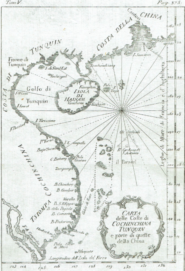
3 Antique Map Of The Costes Of Cochinchina Tunquin And Part Of Those Of China
This exquisite map is a representation of the Gulf of Tonkin and the surrounding coastal regions , featuring intricate details of the area 's top geography . _ It is an interesting and valuable resource for anyone who is interested in the Gulf of Tonkin 's _ history , geography and culture . This map is from the rare work Storia Generale de Viaggi per Mare e per Terra, published in Naples in 1754. The map is a valuable resource for historians and researchers studying the history and geography of Southeast Asia during the colonial period, particularly in regards to trade and navigation in the Gulf of Tonkin. It also offers a glimpse into the evolution of cartography and mapmaking during the 18th century.
Total no. of items: 3
Subject: Antique Map of the Tunquin River and Bay
Author / Illustrator: Van Schley Jakob
Publication year: 1758
Publisher: Didot, Paris
Edition: 1st Edition
DIMENSIONS IN CM (HEIGHT/WIDTH/LENGTH): W19 x L26
Condition: Good condition
Quick bid:
Bid directly
Bids exclude the auction fee and (shipping) costs.
Value:
Value:
Any questions?
?Get in touch via our Help Centre
Buying safely
Payment options
![]()
Share with your friends
![]()
ELEGANT VIETNAM CO.,LTD
UNITED OVERSEAS BANK (VIET NAM) LIMITED
TIN: 0317136923 Duong so 58, V 7 Thao Dien , D2 HCMC Vietnam